The Lackawanna Cutoff - Then & Now
Delaware River Viaduct
The Delaware Bridge at Slateford was lower but longer than the Paulins Kill Viaduct, measuring in at 65 feet high and 1,450 feet long. The contractor had to dig 62 feet below the water surface to find solid rock to support the bridge piers. Interstate 80 now passes under the easternmost arch. An additional two culverts on the west side carried the Cutoff over the "Old Road" of the Lackawanna and Slateford Road. West of those culverts, the Cutoff turned sharply to the north and descended to Slateford Junction.


It is interesting to compare the differences in railroad construction technology of the two railroads. The NYS&W was built in the mid 1800s and it followed the contours of the land. The Cutoff was built in the early 1900s and it literally made its own contours.


Webmaster@GSMRRClub.org Last Updated April 10, 2006
For information about the GSMRRClub, feel free to contact us!
Info@GSMRRClub.org
~~~~~~~~~~~~~~~~~~~~~~~~~~~~~~~~~~~~~~~~~~~~~~~~~~~~~~~~~~~~~~~
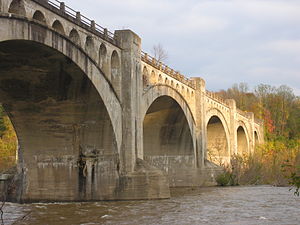
| Coordinates | 40°56′15″N 75°06′21″WCoordinates: 40°56′15″N 75°06′21″W |
|---|---|
| Carries | Lackawanna Cut-Off |
| Crosses | Delaware River, I-80 |
| Locale | Between Portland, PA and Columbia, NJ |
| Characteristics | |
| Material | Reinforced concrete |
| Total length | 1,452 feet (443 m) |
| Width | 34 feet (10 m) |
| Height | 65 feet (20 m) |
| Longest span | 150 feet (46 m) |
| No. of spans | 9 |
| Piers in water | 6 |
| History | |
| Designer | Abraham Burton Cohen |
| Construction start | August 1908 |
| Construction end | December 1, 1910 |
| Opened | December 24, 1911 |

:o)
ROAD TRIP!!! You said it was close. Looks interesting enough to justify a trip. Remember your camera. If anyone wants to look at on google I think it is here: 40°56'16.4"N 75°06'17.2"W
ReplyDeleteMaybe this summer.....
ReplyDelete